Montour
by Sharon McConnel
Occupation in the Montour valley goes back at least 5000 years ago, with archaeological evidence, including a buried pit house and shell middens, suggesting sporadic occupation.1 The elevation of 2500 feet in the river bend must have made it a good wintering location.
Placerville Road
When the mail route was established in 1864 from Falk's Store (Payette County) to Placerville in the Boise Basin (Boise County), the stages passed the ranch door of the Mitchell-Marsh Ranch and it became a waystation for the Boise Basin traffic. William Mitchell homesteaded 196 acres and his brother-in-law Edson Marsh homesteaded 404 acres, roughly between the Placerville Road and the Payette River.2 Mitchell established a post office 1871, which he called Squaw Creek.The name Squaw Creek caused considerable confusion for years. The real Squaw Creek was two or three miles away on the other side of the sometimes belligerent Payette River and there was no bridge.5 The post office name was changed to Marsh in 1889 and it remained open until November 1906.
A ferry also operated in this area during the late 1800's. From the Idaho Territorial Statesman, May 18, 1882, page 3, comes this notice: "Mitchell and Marsh have opened a ferry on the Payette River at Squaw Creek to aid travel to and from the Squaw Creek diggings." April 22, 1892, issue of the Idaho World, p. 4, gives this notice: "Fouch Brothers - Boise County Commissioners set license fee of $36 per year for a ferry located on the Payette River one mile below Marsh Post Office. Bond set at $1000.4
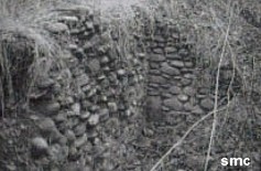
The stone cellar built in the hillside of the Mitchell, Marsh and Ireton Ranch was still in use in 1963.5 Remnants of it are still visible today.
Railroad Era
The area had a new life and boomed with the coming of the railroad. The town of Montour was established by William Dewey, Jr in 1912. "Dewey was building the Idaho Northern railroad up the Payette River from Emmett to McCall. The railroad company platted the town and Dewey's secretary is said to have suggested the name, which in French (monture) means setting or frame, because of its pleasant enviornment."3
After repeated flooding due to the sediment build-up from the Black Canyon Dam, in the 1970's the Bureau of Reclamation bought out the property owners. Today a major portion of the area is a wildlife area maintained by Idaho Fish and Game. The Bureau of Reclamation maintains a park on the old school site.
see also
postmaster history
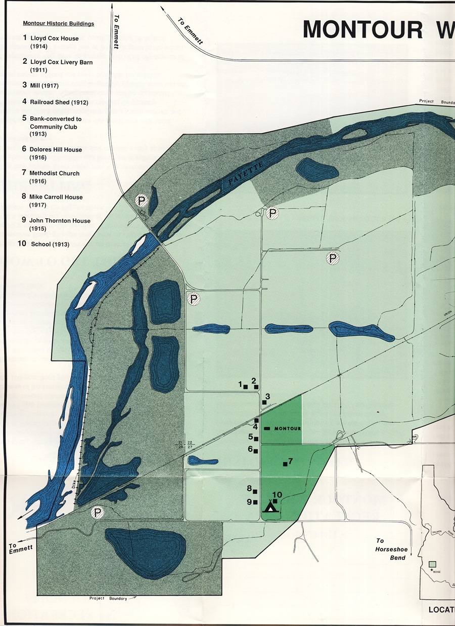
Map of Montour Area from Fish and Game's "Montour Wildlife/Recreation Area Guide
Photographs of the old downtown buildings from From Library of Congress -, American Memory, Built in America collection. (also available at the museum)
Sources:
1History of Archaeological Research, ISU Digital Atlas, excerpt from Prehistory of the Western Snake River Basin (1990) pp.21-38
2The Official Federal Land Records Site
For 1870 map, go to survey plats; then Township 7 North, Range 1 East, then original survey, you'll probably have to pan around the pg & zoom in (keys at bottom) - it shows road to Placerville, & two roads crossing river, one in E 1/2 Sec. 22 & one in NE Sec. 23, both upstream from present day bridge.
3Cort Conley. Idaho for the Curious/A Guide. Backeddy Books, Cambridge, Idaho. 1982.
4Huntley, James L. Ferry Boats in Idaho, Caxton Printers, Caldwell, Idaho, 1979.
5Nellie Ireton Mills. All Along the River/Territorial and Pioneer Days on the Payette. Privately printed for Payette Radio Limited, 1963.
Copyright © 2008 - All Rights Reserved.
Unless otherwise attributed, all photos and text are the property of Gem County Historical Society
Serving Gem County since 1973.
Hours
Wednesday - Saturday 1:00pm - 5:00pm
& by appointment :: Extended hours during The Cherry Festival in June.